Riparian areas are highly complex and dynamic “transitional habitats” that are found along the edge of waterbodies—including rivers, streams, lakes, wetlands, and springs. Riparian areas show steep hydrological and environmental gradients from the water’s edge to the adjacent uplands, and are critical for helping transfer energy and materials between terrestrial and aquatic ecosystems.
Because riparian lands are under the influence of both terrestrial and aquatic processes, these areas tend to be more biologically productive and have higher levels of biodiversity than other habitats of comparable size.
For human communities, riparian areas provide many beneficial ecosystem functions and services. For example, riparian habitats stabilize the banks of waterbodies and help moderate water speeds and high water events, which improves water quality and protects surrounding lands from flooding. Riparian vegetation also slows floodwater and increases floodplain residence times, which increases recharge to groundwater aquifers. In turn, this lets water seep back into streams during low water or drought periods, stabilizing base water flows.
Despite the importance of these habitats, the loss and impairment of riparian lands in Alberta over the last century has been significant. As a result, recent watershed management efforts throughout the province have been focused on identifying priority areas for riparian restoration and habitat management.
In order to efficiently target habitat restoration efforts and resources across large spatial extents, however, reliable information about the location, condition, and function of riparian habitats is required. In response to this need, Fiera Biological developed a satellite-based Geographic Information System (GIS) method that can be used to assess thousands of kilometers of shoreline in a reliable and cost-effective way. This method was developed using metrics comparable to existing methods, and has been validated using both aerial videography and field data.
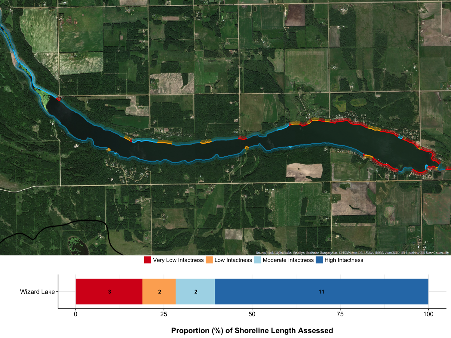
This method uses automated and semi-automated GIS techniques to quantify the intactness of riparian management areas using freely available or low-cost spatial data. This method combines imagery from satellites with information about the terrain (e.g., relative differences in elevation, location of depressions, etc.,) to create a land cover dataset. This information is used to measure and quantify the amount of natural and human cover types present along the shorelines of a water body.
The shoreline is then classified into condition categories along a gradient of how “intact” the vegetation is. Areas that are dominated by natural vegetation are considered highly intact, and areas dominated by human-created land cover types (e.g., roads, houses, agricultural crops) are considered to have very low intactness.
To date, this method has been used to assess over 35,000 km of shoreline in the Athabasca, North Saskatchewan, Battle, and Red Deer River watersheds in Alberta.